
No problem at all!
Hey @azarroyodev, I had a look into that issue and I’m afraid I couldn’t recreate it on my side. The API seems to be returning the correct address for me - see below:
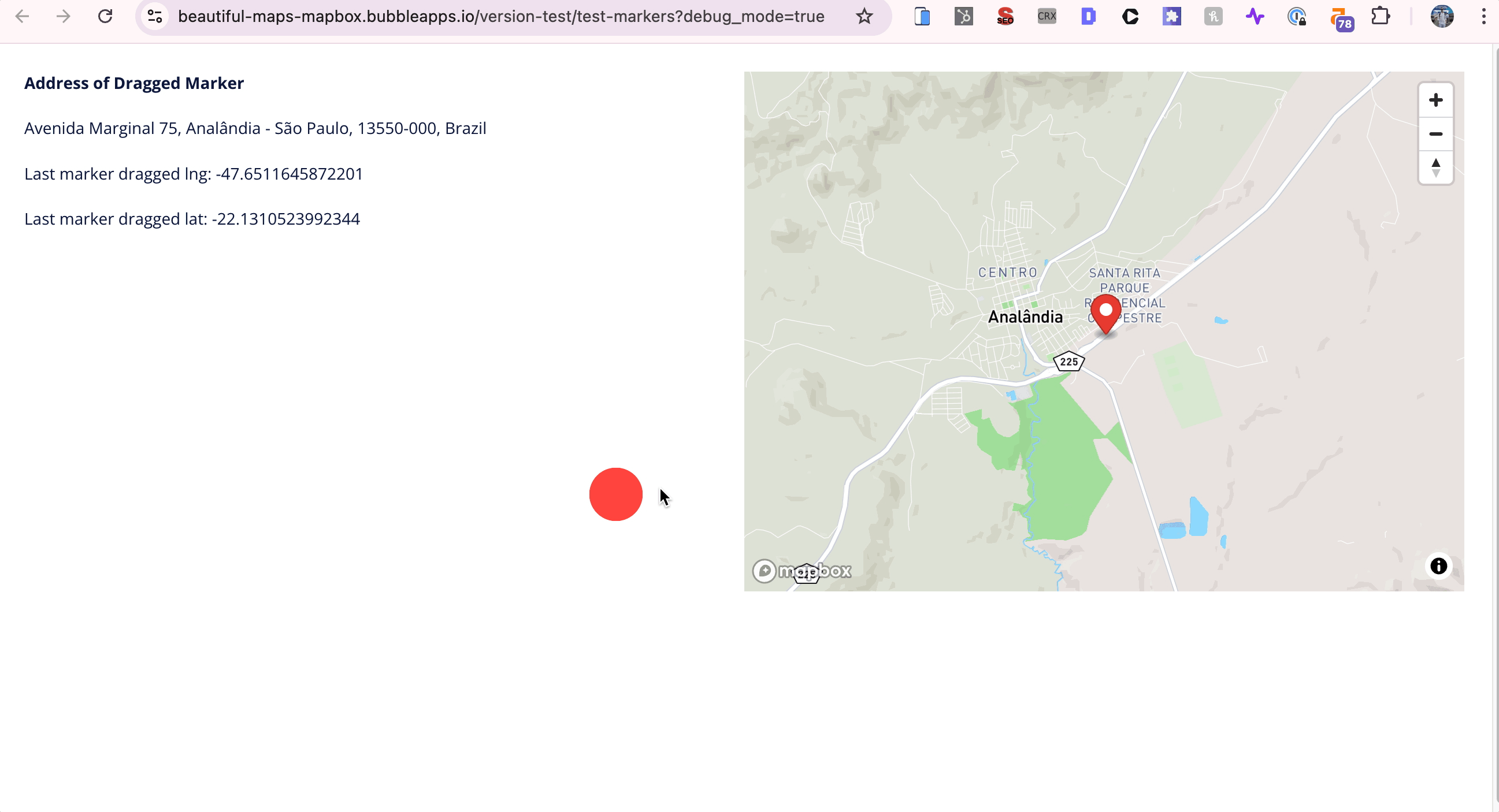
Can you try this out on other addresses and see if you have similar issues?
Hi Alex,
Apologies but I have encountered another issue. The same way I can enable the drawing mode on the map, is it possible to erase the drawings and disable the drawing mode by clicking a button?
What I am trying to do is to reset a map drawing. I can see the “Clear GeoJSON [map element name]” action which in fact does clear out any drawings from the map. But for some reason the map’s area is still there. I know because I have some text filled with dynamic data which tells me the size of the area drawn. Even though I am clearing the drawing from the map, the text still shows the previous total area. The issue is that then this area gets saved in the database even though the user has cleared the drawing… is there a way to erase the total area as well as the drawing?
Hi @Francesca, nice spot - this was a bug.
I’ve just released a new version of the plugin that fixes this. Now when you run the ‘Clear GeoJSON’ action the ‘Area Meters’ and ‘All Lines Drawn (Meters)’ exposed states get reset to 0.
Let me know if that works for you ![]()
Dear Alex,
I hope you’re doing well. Would you be so kind as to advise me on how to configure a search that returns all coordinates within a three-kilometer radius of a specified point? Your guidance would be greatly appreciated.
Thank you in advance for your help.
Best regards,
Moby
Hi @goods2map0415, good to hear from you. I’m guessing you want to add markers to the map for each coordinate that’s within the 3km radius of the specified point?
In order to do this you’ll need to save down the geographic address of each location to your database.
Once you’ve done this, you can filter for coordinates that are within 3 kms of a certain address - see below for an example of how to set this up:

You’ll need to use this filter for both the Longitudes and Latitudes fields.
Let me know if that helps ![]()
Hello! Is there a way to show a radius circle around a pin when the user enters in radius in miles as a number?
Hi @ronnie, thanks for your interest in my Beautiful Maps - Mapbox plugin!
I’m afraid the plugin doesn’t currently support this. Sorry about that.
I don’t have any plans to add this functionality in the near-term, but will let you know if I do.
Any other questions just let me know.
Thank you for your quick response. I’m having an issue with the API Access Token I created in Mapbox.com.
First, the default token works fine when I place the token in the plugin of my Bubble app.

I created a token that is restricted to my URL. This token is not working. Here is what the map looks like:
Here is the version I’m using:
![]()
How can I resolve this? Thank you!
Hi @ronnie, this usually occurs due to an incorrect URL restriction on your Mapbox token.
Can you send me a private message with:
- Screenshots of the tokens section of your Mapbox dashboard (including what URLs you’ve restricted it to)
- The URL of your app
I’ll take a look and see if I can spot anything that looks off.
Hi @alexcooney5,
I am working on developing a native app and wondering if it is possible for the beautiful maps - mapbox plugin to be integrated or if there is a timeline for this yet?
Thanks,
Henry
Hi @henrym, I’m afraid the plugin isn’t compatible with native apps just yet.
Can’t give any firm timeline yet on when it will be as I’m waiting for Bubble to open the mobile plugin editor up to 3rd party SDKs.
No worries, thanks for that.
1 Like
Hi Alex,
Thank you for the fix below, it’s working nicely for me now! I have another question… I have noticed the drawing mode is not working on some iPhones. I upgraded the plugin to the latest version which has improved the useability on my iPhone but for some reason it hasn’t when I test the site from a couple of other devices. Do you have any idea of what could it be?
Thank you again for all the support!
Fran
Hi @Francesca, glad that fix did the job.
Would you be able to let me know which specific iPhones drawing mode isn’t working on? I’ll run some tests on my side.
Hi Alex,
Here are the iPhones that we used and couldn’t seem to get the drawing mode to function:
iPhone 16 Pro. OS version 18.5
iPhone 11 Pro Max. iOS version 18.5
iPhone X
When we tried to draw the polygons on these iPhones none of the anchor points would appear. Not even by pressing the screen for a few seconds. Strnagely when I test it on my iPhne which is an iPhone 13 Pro it worked (I have to press the screen for a couple of seconds).
Let me know if you find anything or have any tips to improve the experience!
Thank you
Francesca
Thanks @Francesca.
Leave this with me and I’ll get back to you later this week with an update.
Amazing, thank you!
Hi @Francesca, I’ve just released a new version of the plugin that should fix that issue you noted with drawing mode on iOS devices.
Let me know if it works ![]()