(more) May-24 updates
Just released a new version of the plugin (version 1.11.0).
The Map element now has a new exposed state called ‘Last Clicked Marker Unique ID’
The ‘Add List of Markers’ action has a new (optional) field called ‘Unique IDs’ (list)
This basically lets you link each marker on your map to the unique ID of the associated location in your database.
The use case for this is if you’re using the ‘When Mapbox Marker is Clicked’ event, you can now trigger a workflow action that changes (or uses) the location associated with the marker you clicked.
Previously, this could be achieved by using the ‘Last Clicked Lng’ and ‘Last Clicked Lat’ exposed states to look up the relevant location in your database.
But that wouldn’t always work if you’re using the offset field to separate out markers that have the same address.
Using the ‘Last Clicked Marker Unique ID’ means that is not longer an issue.
Hey Alex - how about a feature that changes the selected marker icon? Right now, I’m hacking it by overlaying a new marker based on a set of conditions, but as soon as I select another marker, the previous marker still shows.
Add custom styles from Mapbox Studio - July-24 update
Recently released a pretty simple, but very significant, update to the Beautiful Maps - Mapbox plugin.
You can now add custom styles from Mapbox Studio to maps in your Bubble app.
To add a custom style:
Select ‘Custom’ as the Style on the Mapbox Map element and then
Add your style URL to the new ‘Custom Style URL’ field
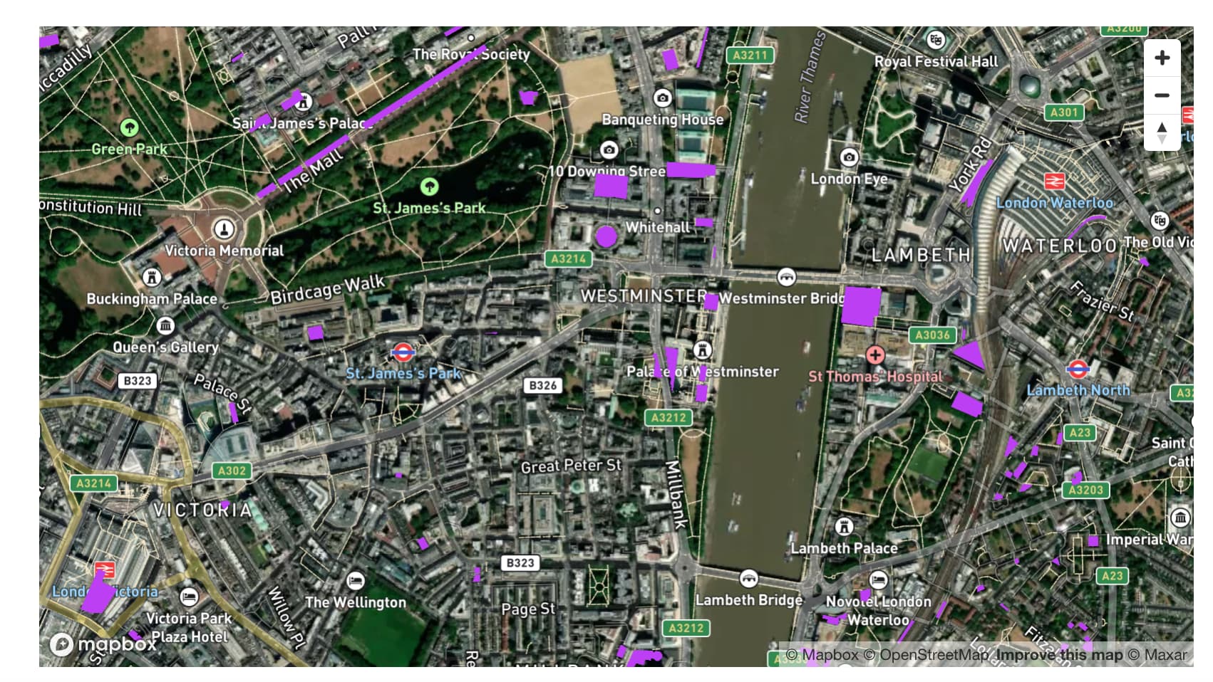
In this example, I’ve created a custom style in Mapbox studio based on the ‘Satellite Streets’ style, but I’ve shown all the ‘Parking’ areas in purple:
Custom Styles Example
Just wanted to share this example of creating custom styles in Mapbox Studio and then integrating them with your Bubble app.
This map shows the population density of all the US states based on the US Census Bureau data (if you want to get technical, it’s called a choropleth map):
Draggable markers - July-24 update
Just released a new version of the Beautiful Maps - Mapbox plugin (version 1.14.0) that allows you to drag markers on the Mapbox Map:
It’s really easy to use. Simply set the ‘Draggable’ field to ‘yes’ on either the Add List of Markers or Add Single Marker actions.
Design custom maps in Mapbox Studio for your app (video tutorial)
Recently released this video on how you can design custom maps (with your own dataset) in Mapbox Studio and then add them to your Bubble app with the Beautiful Maps - Mapbox plugin:
Hello @alexcooney5
I’m so impressed with your work. I’m working on an app where I need to get some info (ex. unique id) about the markers that are visible on current map view. Then, I will use this info to filter my repeating group. Is this something possible?
Another solution could be getting the map boundaries lat & long (in states) and of course these boundaries with change when the user zoom in/out or move the map to other locations.
Please let me know if my idea is already implemented (and i’m not aware) or it is in your road-map.
Hi @melqar, I’ve released a new version of the Beautiful Maps - Mapbox plugin (version 1.15.0). The Mapbox Map element now has 4 new exposed states that allow you to get a Map’s bounds:
North East Lng
North East Lat
South West Lng
South West Lat
These exposed states get updated each time a map shifts - EG see below:
You should be able to use the bounds to determine which of your markers are currently visible on the map itself.
You can also see an example in the ‘Getting a Map’s bounds’ section of the demo app
Can you let know if that’s what you’re looking for?
Hi @alexcooney5 . This plugin is cool. And the videos are really useful. Great work!
Is it possible to trigger a workflow by clicking the pop-up on the map (I know it’s possible clicking on the marker)?
Basically, I’m trying to create a user experience similar to Airbnb or Rightmove where:
(Step 1) the user clicks on the marker, which opens a popup containing summary information and,
(Step 2) the user can click on the popup to open a new tab that contains all of the information.
New events/exposed states for marker hover - August-24 updates
Just released a new version (1.16.0) of the Beautiful Maps - Mapbox plugin that lets you trigger actions when a marker is hovered!
In the above example, I’m showing an alert whenever a marker is hovered. You can see this in the ‘Triggering a workflow when a marker is hovered’ section of the demo app (editor link is here).
By following this approach, you should be able to add in a button/text/other element that allows users to navigate to another page. EG something like this:


")


